
Exploring northern Vietnam on two wheels is a rite of passage for adventurers, and there’s no better route than the legendary Ha Giang Loop. But before the thrill of narrow mountain passes, sweeping valleys, and winding rivers begins, you need one essential tool: a reliable Ha Giang motorbike route map. Whether you’re planning your first ride or returning for a deeper journey, knowing the layout of the loop helps you stay safe, efficient, and fully immersed in the experience.
At Strawberry House, we help riders navigate this epic journey with updated, accurate, and traveler-friendly route guidance. In this guide, you’ll discover everything you need to know about the Ha Giang motorbike route map: how to use it, key stops along the way, route variations, and insider tips from locals who’ve lived the loop.
Why a Route Map Matters on the Ha Giang Loop
While spontaneity is part of the adventure, navigating the Ha Giang Loop without a plan can leave you missing hidden gems or running into unexpected challenges. A detailed Ha Giang motorbike route map gives you:
-
A clear understanding of distance between destinations
-
Guidance on road conditions and terrain types
-
Location of gas stations, repair shops, and medical points
-
Scenic viewpoints and cultural landmarks to prioritize
-
Alternate loops for those with limited time
Most importantly, it gives you peace of mind. Mountain weather can shift quickly, and mobile signal is spotty. A physical or offline map ensures you never ride blind.

The Classic Ha Giang Motorbike Route Map
The traditional Ha Giang Loop usually starts and ends in Ha Giang City, forming a circular or horseshoe-shaped journey through the northern mountains. Key stops typically include:
Day 1: Ha Giang to Yen Minh
Departing the city, the road climbs into the mountains. This stretch introduces you to the region’s karst landscapes and Hmong villages. You’ll pass through Quan Ba Heaven’s Gate, an ideal spot for your first aerial photos.
Day 2: Yen Minh to Dong Van
This section brings dramatic turns, pine forests, and glimpses of the Chinese border. Stop at the Hmong King’s Palace, a historic building with deep cultural ties. Overnight in Dong Van Old Town, where stone houses and market life remain unchanged for decades.
Day 3: Dong Van to Meo Vac via Ma Pi Leng Pass
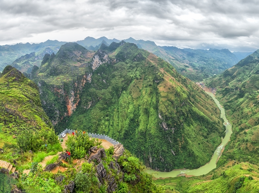
Considered the highlight of the route, this day features the majestic Ma Pi Leng Pass. The road hugs cliffs above the emerald Nho Que River — one of the most iconic views in Vietnam. Drone users and photographers find gold here.
Day 4: Meo Vac to Du Gia or Return to Ha Giang
You can complete the loop or extend to Du Gia, a peaceful village known for its waterfalls and terraced fields. If you have time, this detour offers a restful rural contrast.
Variations of the Ha Giang Motorbike Route Map
No two riders take the exact same path. Depending on your time, skill level, and interests, your Ha Giang motorbike route map may include:
-
Lung Cu Flagpole Detour: The northernmost point of Vietnam, symbolic and highly photogenic.
-
Hoang Su Phi Extension: For those wanting to witness rice terraces in their full glory.
-
Bac Me Road Exit: A quieter backroad that connects Ha Giang with Cao Bang for those heading eastward toward Ban Gioc Waterfall.
Each variation brings its own flavor, whether it’s tribal markets, riverboat rides, or unspoiled villages.
When to Ride the Ha Giang Motorbike Route
Seasonality plays a crucial role in how the loop unfolds. The dry season, from October to April, offers clear skies, making it the best time for drone footage and safe riding. Summer months, while greener and more lush, can bring afternoon downpours and slippery conditions.
The best Ha Giang motorbike route map includes weather alerts or updates, especially for monsoon months. Ask Strawberry House for the latest local intel before setting out.
Motorbike Types and Preparation
Choosing the right bike for the route matters as much as the map. The loop includes steep gradients, hairpin turns, and unpaved segments. The most common options are:
-
Semi-automatic 110cc–125cc bikes: Ideal for beginners
-
Manual 150cc bikes: Better control on steep descents
-
Off-road bikes: For those wanting to explore beyond paved routes
Ensure your Ha Giang motorbike route map includes fuel station locations. Some areas between Dong Van and Meo Vac are remote and without services for dozens of kilometers.
Strawberry House: Helping You Ride Smarter
At Strawberry House, we provide travelers with route maps that go beyond GPS lines. Our staff updates paper and digital maps regularly based on weather, road maintenance, and traveler feedback. We also offer:
-
Offline map apps pre-installed on your phone
-
Printed maps with alternate routes
-
Safety briefings on route segments
-
Suggestions for food, photos, and fuel stops
When you stay with us, you’re not just renting a bike — you’re getting the knowledge of riders who’ve done the loop hundreds of times.
FAQs: Ha Giang Motorbike Route Map
1. Is it safe to ride the Ha Giang Loop without a guide if I have a route map?
Yes, many travelers ride independently with a good Ha Giang motorbike route map, but ensure you’re confident with mountain riding and carry offline navigation tools.
2. Where can I get a reliable Ha Giang motorbike route map?
Strawberry House provides updated physical maps and app recommendations at check-in, designed by locals and tested by experienced riders.
3. Can I modify the classic loop using a custom route map?
Absolutely. Many riders tailor their own Ha Giang motorbike route map to add extra nights, explore new villages, or avoid busy roads. Our team helps you build one based on your time and interests.
Cultural Highlights Along the Route Map
Beyond the landscapes and riding thrills, what truly makes the Ha Giang motorbike route map come alive are the people and traditions you’ll encounter. The region is home to over 20 ethnic minority groups, each with distinct clothing, language, and customs.
In Dong Van, visit the vibrant Sunday market, where Hmong, Tay, Dao, and Lo Lo people gather in colorful attire to trade textiles, livestock, and handmade tools. These markets aren’t tourist shows — they are the living heartbeat of the mountains.
At Lung Tam village, located near Quan Ba, you can witness traditional hemp weaving by Hmong artisans. The craft is centuries-old and done entirely by hand, from planting to fabric dyeing. For culturally inclined travelers, your Ha Giang motorbike route map should include detours to these living heritage sites.
If you pass through Du Gia, consider joining a family dinner at your homestay. Many villages welcome travelers not just to sleep, but to participate in daily life — cooking, farming, or simply sitting by the fire as corn wine is poured and stories are shared.
Photographic and Drone Opportunities
Every twist in the Ha Giang Loop reveals a new angle — from mist-covered peaks to emerald valleys — making it a paradise for photographers and drone users. A well-marked Ha Giang motorbike route map can help you time your day to catch:
-
Sunrise at Quan Ba Heaven’s Gate: With low clouds filling the valley, it’s one of the best drone shots in the region.
-
Golden hour at Ma Pi Leng Pass: The cliffs glow with warm light as the Nho Que River snakes below.
-
Terraced rice fields in Hoang Su Phi: Best between September and October, when fields turn gold.
While photography can be spontaneous, many of the best shots require you to plan your route according to time and light. That’s where a detailed Ha Giang motorbike route map becomes more than a navigation tool — it’s a visual storytelling guide.
Safety Considerations for Route Planning
The Ha Giang Loop is as thrilling as it is unpredictable. To ride it responsibly, your map should also include risk zones and contingency routes. Some parts of the loop can become impassable after heavy rain or landslides, particularly between Du Gia and Meo Vac.
Helpful tips to keep in mind:
-
Always check with locals or your host at Strawberry House about road conditions each morning.
-
Keep a few emergency contacts written down — including nearby mechanics and homestays.
-
Ride slowly on gravel segments, especially near cliffs without guardrails.
-
Carry rain gear and waterproof bags during monsoon season (May–August).
Having a Ha Giang motorbike route map that highlights safe rest stops and fuel availability ensures you’re prepared even if weather or mechanical issues arise.
Offline Navigation Apps and Digital Maps
While paper maps are great for visualizing the big picture, pairing them with digital apps makes the journey smoother. Apps like Maps.me and Organic Maps allow you to download detailed offline versions of the Ha Giang region, which often include elevation profiles, waterfall trails, and even hostel reviews.
At Strawberry House, we help travelers set up their offline navigation before departure. We preload maps with pinned points of interest, such as:
-
Repair shops in Yen Minh and Dong Van
-
Hidden photo spots near Nho Que viewpoint
-
Fuel stops between Meo Vac and Du Gia
-
Local eateries popular with experienced riders
You can request a custom Ha Giang motorbike route map tailored to your travel style — whether you’re focused on scenery, culture, or speed.
Sustainable and Respectful Riding Practices
As Ha Giang’s popularity grows, so does the need for responsible tourism. Many parts of the loop pass through protected areas and fragile ecosystems. Respecting the environment and local customs should be part of every route plan.
Ways to travel respectfully:
-
Don’t litter, especially in remote mountain villages.
-
Use your horn sparingly and avoid loud group rides at night.
-
Dress modestly when stopping in villages or sacred sites.
-
Never photograph people without permission — always ask first.
-
Support local economies by buying handmade products and staying at family-run homestays.
By integrating sustainable practices into your Ha Giang motorbike route map, you ensure that the loop remains wild, clean, and welcoming for generations of riders to come.
How Strawberry House Supports Your Journey
Strawberry House isn’t just a place to stay — it’s a launchpad for exploration. Every rider who checks in receives a full safety briefing, route recommendations based on the current season, and access to our updated route map database.
Our team can assist with:
-
Personalized route planning for 2–7 day itineraries
-
Real-time weather and traffic updates
-
Group ride coordination and guided tours
-
Helmet, bike, and rain gear rental
-
Connecting you to local guides and cultural activities
We believe that the best rides aren’t just about speed or scenery — they’re about meaning, memory, and connection. Our Ha Giang motorbike route map is designed with that philosophy in mind.
The Ha Giang Tour isn’t just a motorbike ride — it’s a journey through time, culture, and nature. With the right map, you move beyond being a tourist and become a true explorer. You can take the back roads, stop where others ride past, and discover what few get to see. So, whether you’re riding solo or with friends, with a drone or just a sense of wonder, don’t leave Ha Giang without your map in hand — and your spirit open.
Find out more about custom Ha Giang motorbike rental route map options and start your loop with confidence at Strawberry House today.
STRAWBERRY HOUSE


